My father was one of the inventors of the undersea fiber optic cable, and joined many of the cable laying missions, including the original Australia mission and several japan missions. (I forget the cable names)
Our house growing up was full of cable segments, superconductors, lasers, and microscopes. I remember one day he brought home a $100,000 microscope that had been thrown away, which I proceeded to use to look at banal things like leaves and insects, but was designed to look at the ends of cut fibers.
Anyway, its incredible to me how much these cables have transformed the world, and how invisible it is to all of us. Imagine if trans-continental communication relied on satellites? The global internet we have today would be much more isolated, with fiefdoms based on proximity.
For those interested in a fiber science story:
He once was asked to calculate the rate of seawater diffusion into glass, which he and the team found ridiculous, but I suppose it was unknown if water could soak into glass in an appreciable way over long periods of time. (Water is an important impurity to try and control)
How would you measure such a thing? There's no good way to increase the rate of diffusion of water into glass, but what you can do is make fiber with excess water in the core, and heat the fiber while measuring the diffusion of water out of the core into the outer portions of the fiber.
Then simple rate relations imply the rate of diffusion at sea floor conditions.
I believe the result was that you would see a 1% increase in the water concentration in the fiber over a period of 10,000 years. So his instinct, that it does not matter, was incredibly correct.
I hope nobody else has ever had to repeat such a measurement!
Just on everything. It adds zero usability or information, it just hinders reading.
Normally I just try to ignore things like this but now this got me wondering: I assume at some point someone convinced someone else this was a must-have, a deal was made, things were implemented, money spent. Would such person/group honestly believe this is better (and in what way) than a static site? Or would this rather be a more calculated move like being able to charge/earn more because it takes longer to implement?
There's also that aspect of building, or creating in general, where if you have more tools, which are easily accumulated on a computer but also in a workshop or creative studio, you'll tend to find a use for them.
I've often found myself in the midsts of a caffeine binging thinking: I've definitely over complicated things for myself here.
In a similar way that the job isn't finished in the workshop until you've cleaned up, overly complicating software has a long tail too.
That's a good point actually. I've had my fair share of complete overkill designs in the past myself. Once I learned the problems it creates years later in large codebases I actively try not to do that anymore though. And to fix the earlier mistakes. Which is also fun: it's not uncommon to fix issues and even implement new features, yet end up with a diff showing more lines deleted than added.
Or a nature documentary. It's only been in the past few years that we're more than a random fault or shark attack away from losing most of our bandwidth to the rest of the world...
That is my favorite Wired article written by my favorite author at that time in my life, and right around the time when the internet started to gather steam, brings back a lot of nostalgia
In similar vein I enjoyed 1994 Neal Stephenson “In the Kingdom of Mao Bell” article in the Wired about CT2 (DECT like cellphone technology) deployment in China/Shenzhen. Even had obligatory “Snow Crash’s Neal Stephenson Visits Shenzhen” magazine cover tag line.
“Even people who carry cellphones carry pagers, which confused me until I found out that most of the cellphones I was seeing aren’t really cellphones at all; they are CT2 phones, which are cheaper and operate over a much shorter range. On a CT2, you can call out but you can’t receive calls, so you have to carry a pager. To cover a metropolis with CT2, tens of thousands of base stations would be needed. Coverage in Shenzhen is still spotty. When you see half a dozen young men loitering on the front steps of a building shouting into their prawns, you know there must be a CT2 station inside.”
Wow wow wow thank you for linking this! Never read it before, and besides being a fine example of Stephenson’s writing it is quite prescient considering what’s happened in HK
"Vietnam veteran Doug Shaftoe, the son of Bobby Shaftoe, and his daughter Amy, do the undersea surveying for the cables and engineering work on the haven, which is overseen by Goto Furudenendu, heir-apparent to Goto Engineering". My all time favorite book.
Why are there submarine fiber cables to ultra-remote islands with barely any population? How do the economics work to make that happen?
Apparently NASA funded the Svalbard cable [0] because it supports a satellite ground station.
The St. Helena government contracted a branch of a Google cable [1], in part, "to attract Digital Nomads to live and work on St Helena" (an HN thread discussed this aspect [2]).
The island of Røst, off to the north west of Norway, has about 500 inhabitants, a subsea cable, and a remote controlled airport. I don't know if the cable is a hard requirement, but I imagine it is helpful to ensure stable airport operations.
Svalsat earth station and kongsberg satellite services (a pretty big defense contractor) are on svalbard. Lots of critical DoD and earth observation stuff is in polar and SSO orbits.
As for other submarine cables to medium size islands, it's a calculation based on a Telco, that until the advent of o3b, might have been paying $300,000 a month for geostationary transponder space. And the much fatter pipe that is fiber. In some cases partially government subsidized as an essential thing since remaining 100% dependent on satellite is a bad thing if you can afford to avoid it.
I want 8 ft tall maps for my wall that I can rotate through. Does anyone recommend somewhere to get A) a submarine cable map of this size and B) other geographical maps of this size?
I don’t care about super high quality paper but I do want lots of detail so it’s fun to lose yourself in.
I have one map from the time when I worked in AWS, it has all the undersea cables displayed (the state as of 2018.) and is about 2x1.5 meters in size.
Cool stuff to have hanging on the wall in the home office.
You can’t really tell who is using a cable without access to quite a bit of contractual data.
Cable capacity is generally leased as strands, then subleased as waves, then someone leases L2 circuits on top of that. Not like L3 where you can run a traceroute or whatever, though I wonder if you could determine possible cables based on latency…
You can pick up clues from router names and domains. For instance if I try traceroute riotimesonline.com I can see routers with "telehouse" in the name (telehouse being the big London interconnect), then a couple of "atlas.cogentco.com" routers, one of which ("lon13") has 10ms ping, and the next ("bos01") has 77ms ping. The next hop seems to be to Amazon Data Services in Boston, so presumably the riotimesonline.com site is being served by AWS out of there, or at least it is for people not in Rio. That tells you who is leasing the transatlantic service. Unfortunately I can't instantly find a web server in Rio to ping.
> connecting Brazil to Europe in less than 60ms of latency
Wow that would be awesome when it's fully operational. I sure hope we in the southeast asia region had that kind of latency to both europe and america (both are around 200ms from here).
How does one transmit power across an ocean? It seems like we are just barely able to send DC across the English Channel with our current technology. Does a global power grid involve super lasers? Or some kind of huge plasma cannon?
HVDC can go much further than across the Channel. Suncable is scheduled to go live in 2027. It will connect Australia with Singapore (3350km), the plan being that Australian solar arrays will provide 20% of Singapore's power. The current longest is 2500km [2] inside Brazil.
A few years ago I saw a talk by an industrial chemist, long distance power transmission over carbon nanotube cables. Looks like they're still not ready for primetime.
Apart from the sophisticated communications technology that goes into achieving maximum throughput through these long distances, is the power supply of the cables.
These cables have an optical amplifier every 50-100km which are supplied by DC power supplied through the protective metal armor around the fibres. Now if you think about it, what is ground if you have a cable between continents? There is no such thing as global ground, so there can be potential differences between of thousands of Volts.
Another one, how do you repair a broke cable that lays at a depth of 500m? TLDR, you bring both ends to the surface and splice a 1km of new cable between them. There are some videos from subcom (former TE subcom) on YouTube.
Sorry what I meant is that if you just connect to the ground on one continent you might have a huge potential difference, compared to the ground on the original continent. So if you would want to run your system on e.g. 100 V you need to make sure that the relative difference between your two end-points is 100 V and that voltage is unrelated to the voltage to ground at either endpoint.
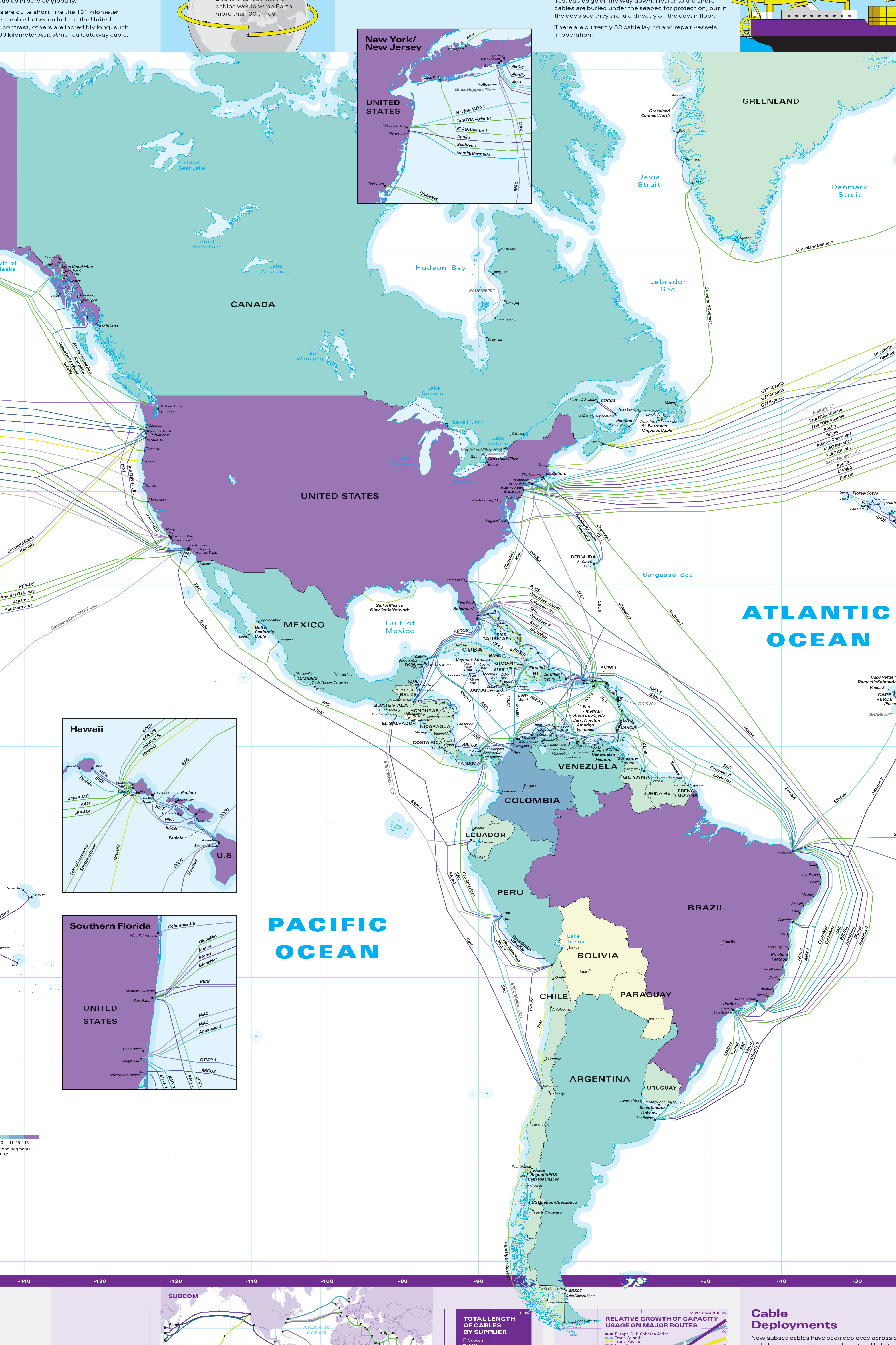
One thing I keep wondering when I see maps like this: Are they a physically accurate representation (e.g. of how separated the North Atlantic cables get), or are they symbolic representations (e.g. like the London Underground map)?
“Are the submarine cable paths shown the actual route taken by the cables?
No. The cable routes on our map are stylized and do not reflect the actual path taken by systems.
This design approach makes it easier to follow different cables and discern their landing points. In real life, cables that cross similar areas of an ocean take similar paths. These paths are chosen after comprehensive marine surveys that select routes to avoid hazardous conditions, which could potentially damage a cable.”
Talk about Baader-Meinhof, was just wondering last night how my messages get routed to friends and relatives overseas. Fascinating find, thanks for sharing
The UI is so well done!
I wonder how the effect of zooming in on certain portions of the map when you scroll to certain sections is achieved.
EDIT: I used it on desktop so it works well for me but can see how mobile users would be less than impressed.
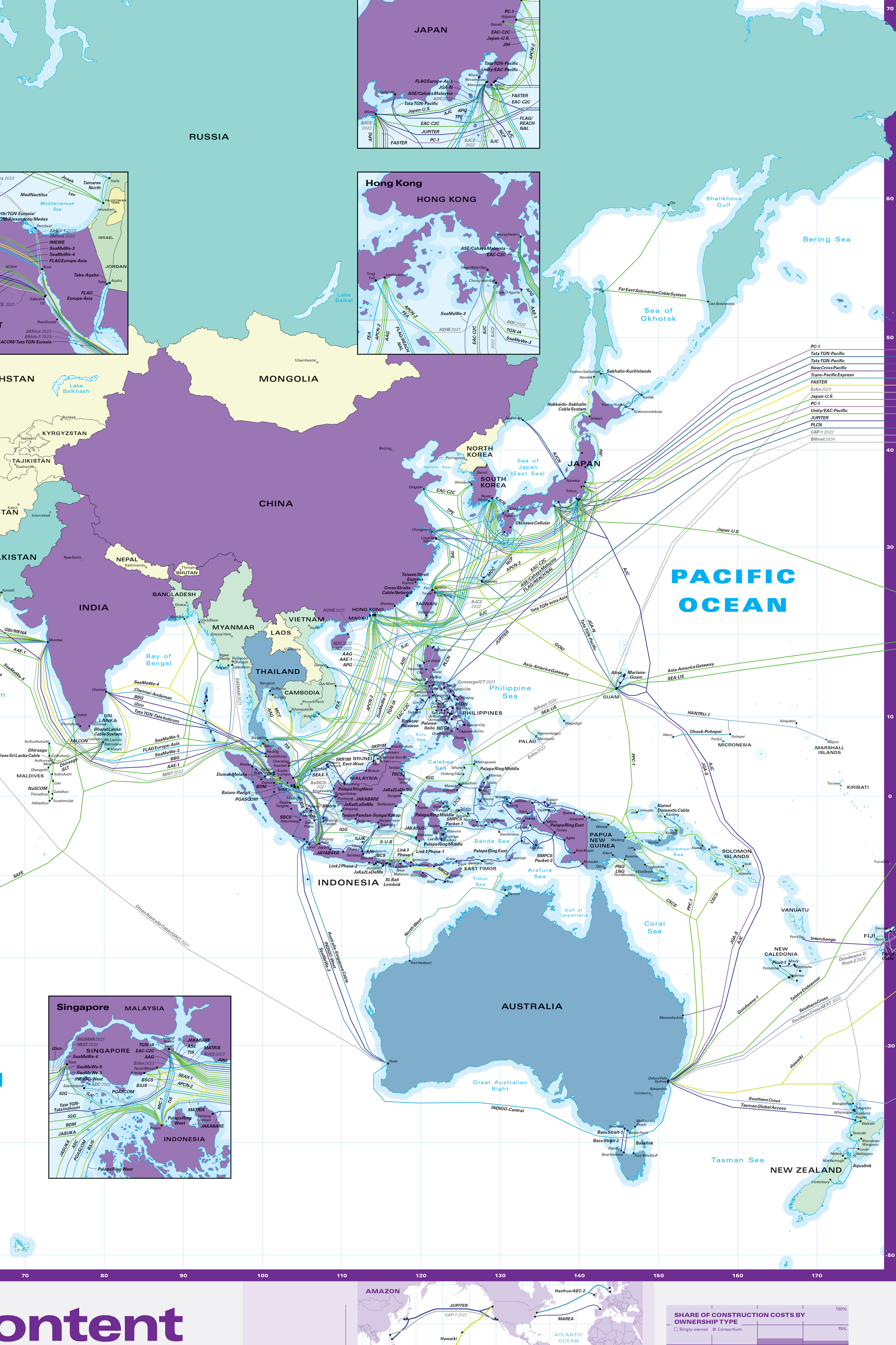
Mining [1] worth $160+ billion per year. There are mammoth automated iron ore mines in that area [2], with railways to Port Hedland [3]. No doubt their communications links follow the railway alignment to Port Hedland, then join the undersea cable to Darwin, then back to head office.
The extra loop heading north is probably the Greater Sunrise gas fields.
It’s just offshore oil and gas platforms. Major iron ore has its own rail track and fibre network. There is no reason for it to loop around, cables are two directional.
Could it be connected to some offshore oil rigs in that region? There doesn't seem to be any islands in that area, but if I'm not mistaken, that part of water is an oil and gas producing region.
I was also wondering where in Oxford Falls the cables land. Oxford Falls is a small suburb north of Sydney and it is ... Inland and high up.
There are multiple satellite dishes from Optus, Telstra and others in Oxford Falls on Oxford Falls Rd but then there are the Oxford Falls falls and other suburbs before it reaches the ocean.
I don't think they work on desktop either. It seems to be just a static image in the background rather than an interactive map (despite the apparent zoom buttons).
Remember this is a "submarine cable map", there are land fiber paths as well e.g. through Mexico. That being said going over to Florida is the shorter path for most of the central/southern US as Central/South America is farther East than most imagine.
AliExpress being slow is more likely a function of latency due to distance than connectivity or bandwidth. On bandwidth remember these lines represent cables, not the amount of bandwidth on the cable. 1 high capacity cable may be easily worth 100 of another on this map. On connectivity remember, much like South America being farther to the right, if you look on an actual globe instead of a flat projection the fastest path from China to the US is to go up to Japan not directly across the Pacific so adding connectivity there would not help.
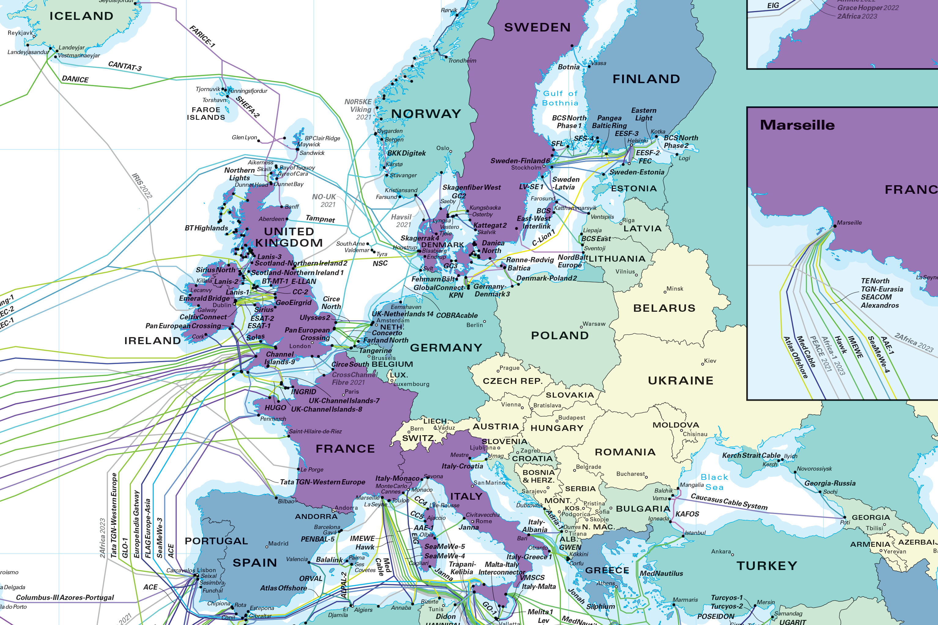
As with most maps this map is missing many current and upcoming cables. E.g. I'm pretty sure Iceland has an additional submarine path or two not accounted for here. For land maps I've never seen anything remotely close to being complete (no fault of the map makers, most of the data just isn't accessible).
> Australia needs more global connectivity. IIRC, data transiting outside of AU is relatively expensive.
> China needs more connectivity, especially with the US for e-commerce (AliExpress is very slow).
To both of these points, yes and no.
- Population of Australia + NZ is about 30M people. While that's not nothing, 30M people don't require the same scale of deployment as serving India, or the US / Canada / Mexico.
- How much traffic to/from China is there in practice (given the Great Firewall, so it's largely unidirectional)?
Pinging aliexpress.com, I get ~100ms latency from US East Coast. From mtr, it turns out that I'm being served out of Germany ("alicloud-ic338528-ffm-b1.ip.twelve99-cust.net"; Telia uses ffm to denote Frankfurt). So latency to/from China is actually irrelevant here.
If you want to serve users faster, you need to invest in content delivery (whether that's buying from Akamai or other players in the space, or building out your own, as AliExpress has done -- I have a much lower ping to img.alicdn.com, which serves me out of New York).
CDN usage also lowers egress bandwidth costs, since you use transit links less (cachefill is expensive but infrequent compared to fetches from cache).
Either way -- higher latency dictates lower steady-state throughput; that said, most requests are short and dominated by start-up costs from e.g. TCP handshaking (especially in the world of larger initial congestion windows), so if you have +100ms latency, that's very visible in terms of flow completion time.
To some of your other points -- SE Asia has a lot of connectivity because it's one of two ways into India (the other way around the world goes through the Middle East, which is fraught with geopolitical tensions). Iceland is a convenient landing point en route to northern Europe. The other way to get from south-central US to South America is through LAX->SCL (Los Angeles -> Santiago, Chile).
Our house growing up was full of cable segments, superconductors, lasers, and microscopes. I remember one day he brought home a $100,000 microscope that had been thrown away, which I proceeded to use to look at banal things like leaves and insects, but was designed to look at the ends of cut fibers.
Anyway, its incredible to me how much these cables have transformed the world, and how invisible it is to all of us. Imagine if trans-continental communication relied on satellites? The global internet we have today would be much more isolated, with fiefdoms based on proximity.
For those interested in a fiber science story:
He once was asked to calculate the rate of seawater diffusion into glass, which he and the team found ridiculous, but I suppose it was unknown if water could soak into glass in an appreciable way over long periods of time. (Water is an important impurity to try and control)
How would you measure such a thing? There's no good way to increase the rate of diffusion of water into glass, but what you can do is make fiber with excess water in the core, and heat the fiber while measuring the diffusion of water out of the core into the outer portions of the fiber.
Then simple rate relations imply the rate of diffusion at sea floor conditions.
I believe the result was that you would see a 1% increase in the water concentration in the fiber over a period of 10,000 years. So his instinct, that it does not matter, was incredibly correct.
I hope nobody else has ever had to repeat such a measurement!